

Description
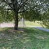
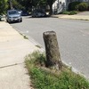
Are the neighbors squatting, fencing, chaining-off, & dumping on the "00 Block" of Westvale Road (shown in MassGIS as a recorded street called "Avenue of Memories")?
This would make a natural way to walk to work or care at Lawrence Memorial if it were maintained as the public way that it appears to be.
As it is, it seems to be used for dumping construction rubble and parking stuff.
Image is from:
http://maps.massgis.state.ma.us/map_ol/oliver.php
With Medford Property Tax parcels (in purple) overlaid on the Orthos 2013 - 2014 base map.
also asked...
Q. What are the items that have been dumped (check all that apply)?
A. Other (please describe in the description field)
A. Other (please describe in the description field)
Q. Is the issue on public or private property?
A. Public
A. Public


10 Comments
City of Medford (Verified Official)
KevinCuddeback (Registered User)
KevinCuddeback (Registered User)
Closed Voice of Medford (Registered User)
Reopened KevinCuddeback (Registered User)
Closed Voice of Medford (Registered User)
Reopened KevinCuddeback (Registered User)
Closed Mike - Code Enforcement (Verified Official)
Reopened Mike - Code Enforcement (Verified Official)
Closed Mike - Code Enforcement (Verified Official)